 One Click...
to all things local!
Riverside Trail
A project by S.P.U.R. (Society for Preservation and Use of Resources)
We are building Riverside Trails for your use
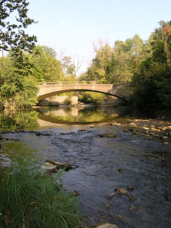
 At the end of North 17th Street, two blocks north of N. J Street in Richmond you'll find the public entrance to a S.P.U.R. project called Riverside Trails. In this area our trail is shared with at least one lodge of beavers, which are industriously working to de-forest the riverbanks. These wild creatures and many more are currently over-flown by an opportunistic colony of turkey vultures that diligently clear away any carrion appearing along the riverbank. Here also Great Blue Heron frequently glide between the trees, pausing to rest on the low branches just above the water.
What's Happening Now?
 Between North 12th Street and North 24th Street Riverside Trails provides over one mile of primitive hiking trails. Between North 12th and North 24thth Street, the twelve foot wide half-mile trail has been cleared and has been carpeted with wood chips to deter weed growth and provide a comfortable walking surface. The riverbank trail requires at least three structures: a crossing over spring-fed quicksand, and two sets of step assists for steep areas where drainage causes trail surfaces to be slick.
What Happens Later?
In the long term Riverside Trails will connect the Whitewater Gorge Trail to Hayes Arboretum and Glen Miller Park. Imagine a trail similar to the S.P.U.R. Trail at the south end of our Whitewater Gorge Park extended throughout our city.  It took many years to inaugurate the Gorge Park and to finish the S.P.U.R. section of the Whitewater Gorge Trail but it was clearly worth the wait.
What Can I Do?
Cut weeds, pick up litter and debris, join S.P.U.R. or simply send a contribution for Riverside Trails to S.P.U.R.. Your tax deductible memberships and contributions are badly needed and most welcome.
S.P.U.R. (Society for Preservation and Use of Resources)
4910 Shoemaker Road
Centerville, IN 47330
Tell Me More!
Want to learn more about the history of the Riverside Trails area?
- Visit Morrisson-Reeves Library's web page on Morton Lake in their "Lost Richmond" section.
- View Photos
Map
View Riverside Trail in a larger map
![]()
![]()
![]()
![]()
|
This jQuery slider was created with the free EasyRotator software from DWUser.com.
Need a powerful Flash slideshow creator with built-in iPhone/iPad/Android support? EasyRotator is supported by the XML Flash Slideshow v4 Software. OK |
This jQuery slider was created with the free EasyRotator software from DWUser.com.
Need a powerful Flash slideshow creator with built-in iPhone/iPad/Android support? EasyRotator is supported by the XML Flash Slideshow v4 Software. OK |
|
This jQuery slider was created with the free EasyRotator software from DWUser.com.
Use WordPress? The free EasyRotator for WordPress plugin lets you create beautiful WordPress sliders in seconds. OK |
This jQuery slider was created with the free EasyRotator software from DWUser.com.
Use WordPress? The free EasyRotator for WordPress plugin lets you create beautiful WordPress sliders in seconds. OK |
Featured Member
S.P.U.R. (Society for the Preservation and Use of Resources)
Community Photo
More Photos:
Wayne County | WayNet Albums
Did You Know?
Wayne County Fast Facts
| Location: | East Central Indiana, USA |
| Founded: | 1810 |
| Population: | 66,456 |
| Elevation: | 1,257 feet Highest Point in Indiana |
| County Seat: | Richmond |
| Local Time: | |
| Date: | |
| About Indiana: | IN.gov |
| Current Weather: |
Follow Us
Contact Us
| Email: | info@waynet.org |
| Phone: | 765.939.0857 |
| Mail: | 50 North 5th St. Richmond, IN 47374 |
| Director: | Board of Directors |
Stay in Touch
Sign up for WayNet News
- our e-newsletter.
Translate This Page
Join WayNet
About WayNet
Waynet, Inc. is a non-profit, 501(c)4 corporation that is fully-funded through memberships. Please support our members and let them know you located them via WayNet.org.
Top 25: popular pages & circulation information.
Our Recent Tweets
Copyright © Waynet, Inc. 2022, All Rights Reserved.| Policies
Directory | News | Discover | Find It Fast | Knowledge | To Do | Members


